


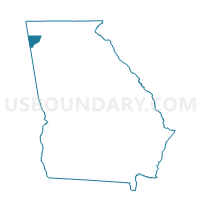
055XC-968-CLOUDLAND Voting District, Chattooga County, Georgia
About
Outline

Summary
| Unique Area Identifier | 560605 |
| Name | 055XC-968-CLOUDLAND Voting District |
| County | Chattooga County |
| State | Georgia |
| Area (square miles) | 40.95 |
| Land Area (square miles) | 40.94 |
| Water Area (square miles) | 0.01 |
| % of Land Area | 99.98 |
| % of Water Area | 0.02 |
| Latitude of the Internal Point | 34.54193170 |
| Longtitude of the Internal Point | -85.44749450 |
Maps


Graphs
Select a template below for downloading or customizing gragh for 055XC-968-CLOUDLAND Voting District, Chattooga County, Georgia


Neighbors
Neighoring Voting District (by Name) Neighboring Voting District on the Map
- 055870 - TRION Voting District, Chattooga County, GA
- 055968 - ALPINE Voting District, Chattooga County, GA
- 2950943 - WILSON Voting District, Walker County, GA
- 2951800 - DAUGHERTY Voting District, Walker County, GA
- 2951808 - CEDAR GROVE Voting District, Walker County, GA
- District One, DeKalb County, AL
- Friendship Baptist Church/Mt. Calvery Baptist Church, Cherokee County, AL
Top 10 Neighboring County Subdivision (by Population) Neighboring County Subdivision on the Map
- LaFayette CCD, Walker County, GA (17,451)
- Summerville CCD, Chattooga County, GA (11,699)
- Cedar Bluff-Gaylesville CCD, Cherokee County, AL (7,204)
- Trion CCD, Chattooga County, GA (6,447)
- Valley Head-Mentone CCD, DeKalb County, AL (4,304)
- Kensington CCD, Walker County, GA (3,264)
- Menlo CCD, Chattooga County, GA (2,891)
Top 10 Neighboring Unified School District (by Population) Neighboring Unified School District on the Map
- Walker County School District, GA (65,673)
- DeKalb County School District, AL (57,097)
- Cherokee County School District, AL (25,989)
- Chattooga County School District, GA (24,188)
Top 10 Neighboring State Legislative District Lower Chamber (by Population) Neighboring State Legislative District Lower Chamber on the Map
- State House District 2, GA (49,475)
- State House District 24, AL (48,127)
- State House District 11, GA (47,447)
- State House District 39, AL (46,905)
Top 10 Neighboring State Legislative District Upper Chamber (by Population) Neighboring State Legislative District Upper Chamber on the Map
- State Senate District 53, GA (164,710)
- State Senate District 8, AL (142,128)
- State Senate District 10, AL (125,075)
Top 10 Neighboring 111th Congressional District (by Population) Neighboring 111th Congressional District on the Map
- Congressional District 9, GA (823,583)
- Congressional District 11, GA (794,969)
- Congressional District 3, AL (681,298)
- Congressional District 4, AL (660,162)
Top 10 Neighboring Census Tract (by Population) Neighboring Census Tract on the Map
- Census Tract 102, Chattooga County, GA (6,447)
- Census Tract 209.01, Walker County, GA (5,763)
- Census Tract 104, Chattooga County, GA (5,275)
- Census Tract 9614, DeKalb County, AL (4,304)
- Census Tract 9557.02, Cherokee County, AL (3,872)
- Census Tract 208, Walker County, GA (3,264)
- Census Tract 103, Chattooga County, GA (2,891)